Current Overview :
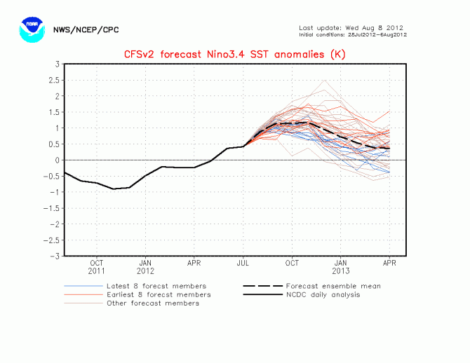
I am focussing all my attention on two main drivers of our climate, the Pacific Ocean, and the Indian Ocean. In the Pacific, we current have warm neutral conditions, with El nino forecast to develop by climate models in the next 2 weeks. However, my forecast is that this is not going to occur, at the moment the atmosphere is decoupled with the oceans and apart from Sea Surface Temperature Anomalies no other indicator is showing El nino tendencies.
CFS still forecasting an El Nino, albeit not strong.
At this stage, im forecasting a cool neutral, as my belief is the warm anomalies in Nino 3.4 have peaked.
The other area is the Indian Ocean, it is in a cool positive phase and has been for a few months, with anomalously cool water sitting off the coast of the Northern and NW part of Australia. However, this is all about to change, as we swing into an early Spring like pattern. Waters will warm in the next month and then continue warming for the next 6 months through Spring and Summer, resulting in very high rainfall for many areas of Australia.
Current sea surface temperatures.
Note the warmth in the Indian Ocean, providing fuel for fronts and low pressure systems over the next few months with a great moisture source. Also, the atmosphere is decoupled from the oceans. All the indicators, the SOI, Easterly trades, thermocline, and GLAAM are all pointing towards neutral rather than responding to the heat in the Nino 3.4 region. In fact recently SST anomalies in the SA coastal regions have cooled right down, as cold SE trades bring up cold water from the subsurface. By mid September we can make a definetive call, but i expect a cool neutral, and well above avergae rainfall again for Australia.
Forecast for Spring:
Northern Territory : Temperatures will be slightly cooler than average through Spring, tending less so in November. Rainfall will be above average through the Northern areas for all of Spring, and average to slightly below average for the remainder of the inland areas.
Queensland: Temperatures will continue to be below average through Spring for all of Queensland except the far north. Rainfall in September will be average through all of Queensland, except the inland which will be below average. However during October and November rainfall will increase substantially for all areas of Queensland.
New South Wales : Temperatures will also follow the trend of most of the country and remain below average for Spring in NSW. Rainfall will be below average in the NW initially in September, then average for the remainder. The remainder of NSW will have average to above average rainfall this Spring.
Victoria : Temperatures in Victoria will also be below average for all of Spring, particularly through Southern areas. Rainfall will also remain above average for all southern areas, and below average for the Northern areas in September, however rainfall will increase through October and November North of the divide.
Tasmania : A continuation of the trend for Tasmania with below average temperatures for the entire period and state. rainfall will be variable, average in western areas and below average slightly in Eastern areas.
South Australia : Southern areas will be below average for temperatures for the entire Spring period. Northern areas will see early above average temperatures through Septmeber and October, averaging out by November. Rainfall will also be highly variable, southern areas will avergae rainfall tending wetter through the latter part of Spring, Northern areas of SA will see below average rainfall until October when rain will increase markedly.
Western Australia : Temperatures will be slightly above average in September and October, particularly through the Southern and inland areas. November will see temperatures average out to normal. rainfall will be slightly above average through the North, slightly below in the South through September. However i expect rainfall to increase markedly through October/November.
Notes: We will see early Spring warmth for most of the inland areas, moving South. Humidity will increase from September onwards, deep Easterly trades should ensure lots of moisture will be advected over the country. Also, towards the start of September the West coast and East coast troughs will fire up and move south a lot earlier than you would expect. The impact of the Indian Ocean warming over the NW corner will be the difference between a normal year and a very wet year. This will need to be watched and updated within a few weeks. I also forecast an early monsoon, which did not arrive in the top end until late Jan this year.

